Brunswick is an inner-urban suburb six km north of Melbourne. Its western and eastern boundaries are Moonee Ponds and Merri Creeks respectively; on its south it adjoins Melbourne city and Yarra city, and its northern boundary is Moreland Road. These suburban boundaries corresponded with the municipal boundaries (1857-1994).
Brunswick was subdivided into farm allotments which were sold in 1839, mostly to speculators. One of them was resold to Thomas Wilkinson and a partner. They named the property Brunswick Park, in honour either of the late Princess Caroline of Brunswick (late wife of King George IV), or in honour of the marriage of Queen Victoria to Prince Albert of the royal house of Brunswick. Place Names of Victoria suggests an alternative source of the name Brunswick. Blake believes that German land speculator W.F.A. Rucker named his property Brunswick after Captain George Brunswick Smyth, officer-in-charge of Port Phillip military police in 1839.
The gold rushes caused a demand for building material in the 1850s. Bluestone was found throughout the eastern half of Brunswick and clay was found west of Sydney Road. An early site of brick and pottery products was at the village of Phillipstown, just east of Grantham Street, in 1852. By the early 1850s the stone quarries were nearly worked out, replaced by brick yards. By 1863 eight brick makers' yards were operating. Farms and large residences were still interspersed with the industry.
Sydney Road was the main route to several gold fields, which further stimulated commercial and civic development. In 1840 Wilkinson donated land in Sydney Road for Brunswick's first (Wesleyan) church, which in turn opened the first school in 1849. The Presbyterians opened a primary school in 1855 and the Catholics in 1860. Several hotels were opened in Sydney Road by the mid 1850s.
On 29 September 1857 Brunswick was proclaimed a municipal district, becoming a borough in later years. Council chambers were built near Albion Street.
In the late 1860s Brunswick's future civic centre became evident around the intersection of Sydney Road and Dawson Street. A mechanics' institute (1868) and St. Ambrose's Roman Catholic Church (1869-71) opened in that vicinity. In 1875 the Presbyterians and the Wesleyans combined to open a larger school, which became the Albert Street or Central Brunswick School.
The land boom in the 1880s resulted in many of the properties being subdivided and some of the mansions demolished. Trains to Coburg started in 1884, and trams along Sydney Road to Moreland Road in 1887. The railway cheaply transported pottery products. Brunswick's population more than tripled in ten years to 21,000 in 1890. Italians began settling in Brunswick in the 1880s, and again in the 1920s and 1930s.
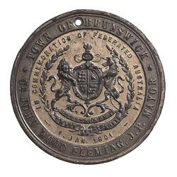
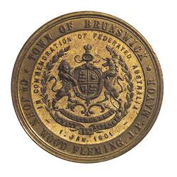
The town of Brunswick was proclaimed on 13 April 1888.
The 1890s depression caused unemployment, exacerbated social divisions and doomed subdivision projects.
In 1897 the first labour political organisation was formed, the Brunswick Branch of the united labour party. The future Australian Prime Minister John Curtain joined the Brunswick Branch, having worked in a pottery and played for Brunswick Football Club. In later years Brunswick's association with left-wing politics was further manifest. In 1931 a branch of the Communist Party formed. It campaigned to stop legislation which would have outlawed free speech and the right of assembly.
By 1902 Brunswick had a population of 24,182 and 5,024 houses on 2,722 acres. It included a wide range of factories including potteries, smelting and gas works.
The city of Brunswick was proclaimed on 15 January 1908.
Until 1916 retailing and entertainment activity concentrated along Sydney Road for its entire length through Brunswick and northwards up into Coburg.
In 1922 the first of Brunswick's many large clothing and footwear factories, Prestige Hosiery, opened. By 1952 this growth culminated in the opening of the large Fletcher Jones factory.
Residential settlement expanded northwards with the opening of a primary school and a railway station in 1924.
Secondary schools in Brunswick included the technical school (1916) and the girls' high school (1924).
Post-war Brunswick was home to many European immigrants. Large numbers of Italians and Greeks settled there, as well as Yugoslavs and other European immigrants. By 1976 the proportions of Brunswick residents of migrant background included Italian (15%), Greek (9.3%), Lebanese/Turkish (4%). Many found employment in textile and manufacturing industries. In 1969 a Greek Orthodox Church replaced a Methodist church.
The 1970s and 1980s saw the loss of local employment and gentrification of Brunswick. Between 1980 and 1995 three-quarters of Brunswick's factories closed.
On 22 June 1994 the Cities of Brunswick and Coburg, and part of the City of Broadmeadows, united to form Moreland City Council.
References:
Victorian Municipal Directory.
Municipal Assocition of Victoria website http://www.mav.asn.au, accessed 20/02/2004.
Blake, L. (1977). Place Names of Victoria.
Australian Places website, Monash University http://arts.monash.edu/ncas/multimedia/gazetteer/list/brunswick.html, accessed 20/02/2004.
More Information
-
Keywords
-
Localities
-
Authors
-
Article types