The Shire of Cranbourne was situated approximately forty six kilometres south-east of Melbourne, focused on the town of Cranbourne. Numerous artefacts indicates that the area was intensively occupied by the Wurundjeri and Boonerwrung people. The Boonerwrung tribal territory covered most of what is now the City of Casey (including the former Shires/Cities of Cranbourne and Berwick, which were amalgamated in 1994), from the coast inland, with the Wurundjeri inhabiting the very northern part of Casey. Seasonal camp sites were located along the banks of rivers and creeks. One important site, including stone artefacts made from quartzite and chat, is today located in the Royal Botanic Gardens, Cranbourne.
The earliest settlers in the area of the Shire of Cranbourne were the Ruffy brothers, who squatted on Mayune run in 1836. They established the Cranbourne Inn, which may have been named after a town in Berkshire, England, or after Viscount Cranborne. Other early pastoralists focused on grazing cattle and growing barley and wheat.
A small community began to develop on 'Mayune', leased by Alexander Cameron, through which the track into South Gippsland passed. The township of Cranbourne was surveyed on the site in 1856. The township was gazetted in 1861. Selectors were now able to purchase portions of the large runs. Farmers began to concentrate on dairying, market gardens and orchards. Infrastructure began to develop, with a school, churches, another hotel and postal service established in the township. The Mornington Farmers' Society, founded in 1856, held ploughing matches and annual shows. Later, the shows were held at Berwick in alternate years.
Cranbourne Road District was created on 19 June 1860 and a Shire proclaimed on 6 March 1868. A Shire Hall was erected about 1875.
Cranbourne experienced a brief flourish of fame in 1860 when several meteorites were discovered in the area. The largest was sent to the British Museum where it is still part of the meteorite collection.
The rail line from Melbourne to South Gippsland reached Cranbourne in 1887. Cranbourne had developed as a market centre for settlers in the outlying Westernport area and as a link with Melbourne, but the train undermined the importance of the town's stock market, as cattle could now be cheaply trucked to Dandenong or Melbourne. Dandenong gradually began to overshadow Cranbourne. However, perishable produce from dairy farms, market gardens and orchards could now be railed to market from Cranbourne, retaining the economic viability of the centre.
The town was the focus of community life. Sports clubs were formed in the 1880s and 1890s. Horse racing, which had a strong following, was boosted when a new course and grandstand were opened in 1881.
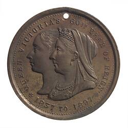
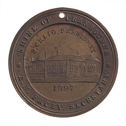
In 1897 the Shire of Cranbourne issued a medal to commemorate the diamond jubilee of Queen Victoria (NU 20468).
In the 1950s industrial development began to spread into the northern part of the Shire from Dandenong. This stimulated housing development at Cranbourne, particularly in the 1980s and 1990s. The population was 1,800 in 1976, rising to 14,005 in 1986 and 18,886 in 1991. Suburban rail services and a freeway now link the town to Melbourne.
In 1994 the Shire of Cranbourne was proclaimed a City but on 15 December 1994 the City of Cranbourne was split between three new councils. The majority became part of Casey City Council with the City of Berwick; parts also went to Greater Dandenong Council and Frankston City Council.
References:
Australian Places website, Monash University, http://arts.monash.edu/ncas/multimedia/gazetteer/list/cranbourne.html Blake, L. (1977). Place Names of Victoria.
Municipal Association of Victoria website http://www.mav.asn.au/, 10/12,2003.
Casey City Council website http://www.casey.vic.gov.au/environment/pdfs/Environment%20Education%20Kit%20Section%202%20-%20Urban%20&%20Cultural.pdf, accessed 10/12/2003.
More Information
-
Keywords
-
Localities
-
Authors
-
Article types