Ferntree Gully, originally 'Fern Tree Gully' because of the scenic gully now partly in the National Park of the same name, is located 32 km east-south-east of Melbourne. The gully became an excursion destination in the 1870s. Land around the gully was reserved for public purposes in the early 1880s, and its popularity increased when the railway was extended from Ringwood to Upper Ferntree Gully in 1889. The reserve became a national park in 1927.
Prior to Europeans settling in the area First Peoples from the Westernport and Yarra Yarra tribes lived throughout the Dandenong Ranges and its foothills during the summer months.
Ferntree Gully was originally part of an outstation established by Rev. Clow in 1840. Settled during that decade, by the 1870s selectors enjoyed the facilities provided by two hotels and a post office. Further eastwards timber-cutters were penetrating the forest, and a school was built in 1880 to meet local needs. Soon a bakery, a butchery and Wesleyan and Anglican churches were built. On 30 May 1889 the Shire of Fern Tree Gully was proclaimed, consisting of 390 sq km severed from the Berwick shire. Its population was 750.
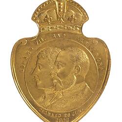
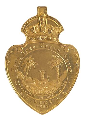
Fern Tree Gully Shire Council issued a medal to commemorate coronation of Edward VII in 1902 (NU 20244). It names R.H. Kerr as Shire President.
By the turn of the century Ferntree Gully had spread, and after World War I Ferntree Gully became a retreat for several prominent Melburnians. Large boarding houses were built for tourists. At the same time cheap land and fibro houses with wood stoves enabled low income people to derive a living, supplemented by back yard vegetables. Electric trains arrived in 1929. A strong arts society was founded in 1944.
Post-war urbanisation saw the building of a kindergarten, a boys' technical school, another primary school and the William Angliss hospital. By the early post-war years only about 20% of Ferntree Gully's workforce were in primary industry; many workers commuted to Melbourne's industrial areas. By 1954 22,019 lived in the Shire.
In 1954 the State Government enacted planning controls over excessive subdivision. Debate over severance of the plains from the hills extended until the 1960s.
Fern Tree Gully shire included Bayswater, Boronia, Lysterfield, Scoresby and Wantirna, all of which were severed on 16 November, 1963, to form Knox shire down on the plains. The severance included the western part of the Ferntree Gully township. The areas remaining in the shire included Avonsleigh, Belgrave, Clematis, Emerald, Ferny Creek, Kallista, Macclesfield, Menzies Creek, Monbulk, Olinda, Sassafras, Selby, Sherbrooke, Tecoma, The Patch, Tremont, Upper Ferntree Gully and Upwey.
On 22 December 1964 the shire name was changed to Sherbrooke shire. On 15 December 1994 Sherbrooke was split between the new Yarra Ranges Shire Council, Cardinia Shire Council and Knox City Council.
References:
Australian Places website, Monash University. Http://arts.monash.edu/ncas/multimedia/gazetteer/, accessed 12/01/2004.
Knox City Council website http://www.knox.vic.gov.au/content.cfm?infopageID=311, accessed 12/01/2004.
More Information
-
Keywords
-
Localities
-
Authors
-
Article types