Gippsland is a unique and diverse region to the east of Melbourne. It comprises snow fields, wilderness, rainforests, beaches, industrialised areas and farmland. The Bratauolong clan and their territory stretched along the southern Strzelecki Ranges and the coastal plain from the Tarwin River and Cape Liptrap in the west to Merriman's Creek in the east, about 5000 square kilometres.
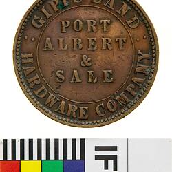
Count Strzelecki arrived in Melbourne in May 1840, after crossing Gippsland from east to west. He was preceded by explorer Angus McMillan. Encouraged by reports of the area, eight men formed the Gippsland Company, chartered a barque and set off for Gippsland. A settlement was soon established at Port Albert as the potential of the area's natural resources was realised.
One of the first settlers in South Gippsland was E.Tucker. The Tucker family became highly prominent and successful settlers in the region.
A whaling station operated in the South Gippsland area c. 1839-47. The opening up of new pastoral lands resulted in the steady growth of Port Albert. The town flourished during the 1850s and 1860s as the major port for cattle and gold export in eastern Victoria. The Bank of Victoria opened in 1856 when gold was discovered in Walhalla. Port Albert became the major gateway to east and central Gippsland between 1841 and 1878, but declined in later years with the improvement of overland routes and the arrival of the railway.
The township of Alberton, from which the old shire took its name, was proclaimed in 1842. The Alberton Road District was created on 6 November 1855; the Shire of Alberton was proclaimed on 2 February 1864. South Gippsland was severed from the Shire of Alberton on 16 February 1894.
In the 1860s exploitation of South Gippsland's natural resources increased. Buchanan's sawmill complex east of Muddy Creek was opened. Timber was brought to the mill on tramways and was also taken to by tram to the port of Corner Inlet, which was to the south of the complex. The population of the mill settlement grew to about 200 people, but the business ceased during the 1870s.
Stone and brick lime kilns were built in South Gippsland in 1875, and remained in operation until 1926. Workers' cottages and a jetty were constructed in the vicinity; remnants of these still stand in the 21st century. In 1903 a timber mill was constructed at Sealers' Cove; remnants of this also exist.
The South Gippsland Sawmill and Tramway company was registered in 1882 with a small steam sawmill at the foot of the escarpment south of Yarragon and 1.5km of log tramway behind the mill; a second mill was soon established. The company was wound up in 1886, however, and the sawmill struggled for another three years under a new owner before economic conditions forced it to close in 1889. The tramway remained in partial use by selectors until 1897.
The railway was extended to South Gippsland in 1891, providing easy transport for cattle and dairy products. Closer settlement occurred in some areas in the late nineteenth and early twentieth centuries.
In the 1920s a tin mine was established at Wilson's Promentary.
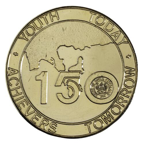
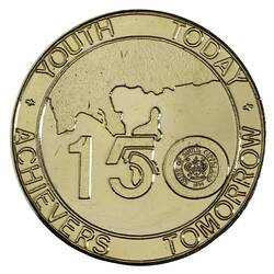
In 1985 the South Gippsland Shire Council issued a medal to commemorate the Sesquicentenary of Victoria (NU 20711).
On 2 December 1994 the South Gippsland Shire Council was formed from the united Shires of Mirboo, South Gippsland, and parts of the Shires of Korumburra and Woorayl.
Corner Inlet Marine and Coastal Park and Nooramunga Coastal Park, in the Shire of Gippsland, have been designated Wetlands of International Significance under the Ramsar Convention.
References:
Blake, L. (1977). Place Names of Victoria.
Municipal Association of Victoria website http://www.mav.asn.au
Victorian Heritage Register website http://www.doi.vic.gov.au
Yarram-Port Albert website http://yarrampa.customer.netspace.net.au/history.html
Maria Brandl website http://home.vicnet.net.au/~marmar/Sandypt/sandypointhistory.html.
More Information
-
Keywords
-
Localities
-
Authors
-
Article types