South Melbourne is located between the south bank of the Yarra River and Port Phillip Bay, some two kilometres south of Melbourne. It originated on an old volcanic outcrop elevated above the surrounding swamp land, first known as Emerald Hill. In summer the swamp land dried out and it could be used for recreation or military training.
In 1852 a survey of Emerald Hill resulted in the auction of subdivided lots. Grants of land were made to the Anglican, Catholic, Presbyterian and Wesleyan churches, and choice blocks were given to the Melbourne Protestant Orphan Asylum. Settlement of Emerald Hill developed quickly, and on 26 May 1855 Emerald Hill was proclaimed the first separate borough outside of Geelong. This was reflected in the town's motto 'In Ordine Primum', translated as 'first in the field'.
At the time of the survey of Emerald Hill in 1852 a temporary township was created on low-lying land west of St. Kilda Road, south of the river. It was known as Canvastown, and provided tents for the large numbers of immigrants who were arriving during the gold rush. It lasted for two years and gave its name to the first school in the area, which opened in 1853 at the corner of Clarendon and Banks Street. Other church-run primary schools soon opened in Emerald Hill: Presbyterian (1854), Catholic (1854), Anglican (1856) and the Orphanages, Protestant (1856) and Catholic (1857). A mechanics' institute was opened in 1857.
In 1854 the Melbourne to Hobsons Bay railway line opened, but it was the Melbourne to St. Kilda line that opened in 1857 that effectively serviced Emerald Hill.
The land around Emerald Hill was still swampy, and remained unsuitable for housing or industry. The Victoria Barracks, on higher land in St. Kilda Road, was built in 1859, and the military freely roamed the area. In 1863 massive floods inundated the surrounding area and the few optimistic infant industries. It took until 1887 for the Coode Canal to provide effective flood control, but land drainage and river works encouraged settlers on the lower lying areas. In the 1870s cottages were built at Montague, but they were still located below road level, and rubbish accumulated in the ill-drained yards. A better housing outlook was created at Albert Park, particularly when the lagoon was excavated to form a lake for recreational boating.
On 1 March 1872 Emerald Hill was proclaimed a town. The council moved its town hall from Cecil Street to the site occupied by the Protestant Orphan Asylum. The orphanage was persuaded to take a larger site at Brighton in exchange.
In the 1870s and 1880s state schools replaced church schools: the Eastern Road school (1877), the Dorcas Street school (1881), the City Road school (1884) and Montague (1889). All became crowded as the population of South Melbourne more than doubled in twenty years, reaching nearly 42,000 in 1891. The population serviced industries along the river, which were mainly noxious, imparting unpleasantness to the growing residential areas. In 1877 the Harbor Trust forced the industries to move downstream, replaced with cleaner manufacturing drawn by the better access across the Falls (Queens Street) Bridge and the construction of South Wharf.
The developing local infrastructure included the Homeopathic (later Price Henry's) Hospital, 1882, and the Immigrants' Home (1852-1911), coming after the health Canvas Town and the Victoria Police beside the Barracks. On the site which would ultimately be the Arts Centre complex there were the Green Mill, Wirth's Olympia and (later) the Trocadero and Glaciarium entertainment venues. In 1883 Emerald Hill became a city and changed its name to South Melbourne.
Clarendon Street emerged as a main retail strip. The Anglican and Presbyterian churches turned their Clarendon Street frontages over to commercial development. Tram lines along Clarendon Street and Park Street were opened in 1890, along with the connection made to the city seven years before with a steam ferry between Clarendon and Spencer Street. Manufacturing and food-processing industries expanded back from the riverside. Food processors included Hoadley's Chocolates (later Allens Sweets) and Sennits ice-cream. Textile mills, timber merchants and furniture trades set up in the 1880s. Clarendon Street, in addition to having many food and drapery retailers, had furniture retailers.
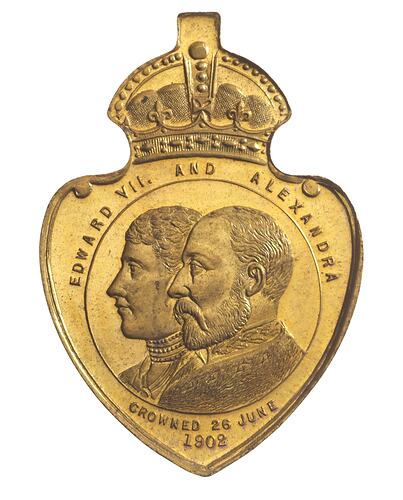
The coronation of Edward VII in 1902 prompted major celebrations in Australia. It was an opportunity for the new nation to reaffirm its pride at being a key member of the British Empire. Over 40 different medals were produced around Australia. A medal was issued by the City of South Melbourne, and names W.J. Mountain as Mayor (NU 20254).
In the 20th century education extended to secondary level with a technical school (1919-92), St. Joseph's technical school (1924-88) and the conversion of the City Road primary school to the Domestic Arts School (1930). Another was the transfer of the Melbourne Girls' High School to MacRobertson Girls' High School, in a corner of Albert Park, in 1934.
South Melbourne became home to many post-war migrants. Cricket and football was played beside the South Melbourne Hellas Soccer Club, and adult migrant English classes were run at the Eastern Road primary school. Riverside industry expanded. In the post-war years Melbourne's central business district spilled down into cheap land in St. Kilda Road.
The first part of the Arts Centre was opened in 1968, having been reserved in 1944. As culture officially came to South Melbourne gentrification came to its residential area. By 1981 the population was less than half its post-war figure. Notable changes since the 1960s have included high-rise Housing Commission flats (Emerald Hill Court, 1962, and Park Towers, 1969), the Westgate Freeway (1975-95) and the development of Southbank. The South Melbourne Gas Works were converted to a park in 1982, and the Castlemaine Brewery became the Malthouse Theatre in 1987.
On 18 November 1993, the area of South Melbourne defined as Southbank and extending to Docklands was annexed to Melbourne city. On 22 June 1994 the Cities of South Melbourne, Port Melbourne, St. Kilda and part of Prahran united to become the Port Phillip City Council.
References:
Municipal Association of Victoria website http://www.mav.asn.au
Australian Places website, Monash University http://arts.monash.edu/ncas/multimedia/gazetteer/list/southmelb.html
Blake, L. (1977). Place Names of Victoria
City of Port Phillip website http://www.portphillip.vic.gov.au/brief_early_history_of_port_phillip_profile.html#L2
More Information
-
Keywords
-
Localities
-
Authors
-
Article types