This is a description of the CSIRAC program that generated a weather forecast for any locality polewards of about 15 degrees latitude.
This was the first computer program in the Southern Hemisphere to generate a weather forecast. Museum Victoria does not have the paper tape program.
Overview
It was observed in the early 1930s that small 'parcels' of the atmosphere at about five-and-a-half kilometres moved so as to preserve their absolute vorticity. This is essentially the 'spin' of the parcel, and has three components: spin of the parcel about its centre, spin of the parcel about some outside location (such as the centre of a cyclone) and the spin imparted to the parcel by the rotating Earth. The sum of the first two is called the relative vorticity, the sum of all three is the absolute vorticity. This observed conservation of spin was given theoretical justification by Carl-Gustav Rossby. He deduced the result for a barotropic atmosphere - that is, one which moved as a block, and in which energy changes were not possible.
In the late 1940s Jules Charney showed that Rossby's assumptions were too restrictive, and that absolute vorticity was conserved for a baroclinic atmosphere in which the velocity could change and energy conversions were possible.
In 1950 Charney, Fjortoft and von Neumann used the electronic digital computer ENIAC to produce the world's first computer generated weather forecast. They named their model the Equivalent-Barotropic Model, possibly because it used Rossby's well-known equation.
Applying this model to CSIRAC, coding and running it for Australian weather maps and conditions, formed the core of Jenssen's Master of Science work under the supervision of Uwe Radok. In September 1958 the first computer generated weather forecast for the Southern Hemisphere was made. Uwe Radok and Jenssen also showed that the model could be used to determine vertical velocities and thermodynamic warming and cooling, which led to a prediction, using the model, of possible rainfall distribution.
Brief description of the model
The troposphere is that region of the atmosphere in which most everyday weather occurs. It is higher in the tropics, up to 20 km, and lower in the polar regions, about 7 km. Processes in the free atmosphere, at a height of roughly 5500m, tend to mirror the behaviour of the large-scale tropospheric events. The Equivalent Barotropic Model deals with the dynamics of the atmosphere at this mid-tropospheric level. The mathematics used is complex, but the only input required is information about the pattern of pressures (the pressure field). Simply put, the winds are determined by the pressure field at about 5500m. The winds, in turn, are associated with a quantity known as vorticity, and this quantity is redistributed by the winds. Because the pressure field determines the winds and vorticity, a new vorticity pattern can be used to find the corresponding new pressures. Repeating this process allows a forecast to proceed to any desired time.
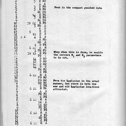
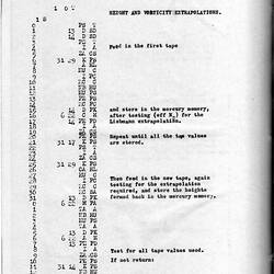
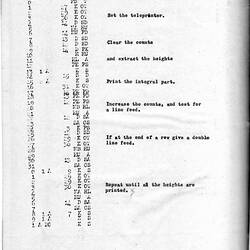
Brief outline of the model algorithm
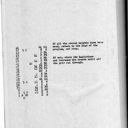
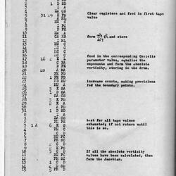
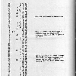
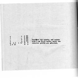
1. From the pressure pattern at about 5000m (which represents the average atmosphere), the winds are computed.
2. Also from the pressure pattern the spin of the atmosphere (absolute vorticity) is found.
3. The wind is used to transport the spins (vorticities) to new locations a short time later. Say this new time is one hour ahead.
4. From these new distributions of spin (vorticities), the new pressure pattern is deduced.
5. This new pattern replaces that in step 1 above.
6. Steps 1 through 5 are repeated until the time advanced is, say 24 hours. That's 24 cycles.
More Information
-
Keywords
-
Authors
-
Article types