Summary
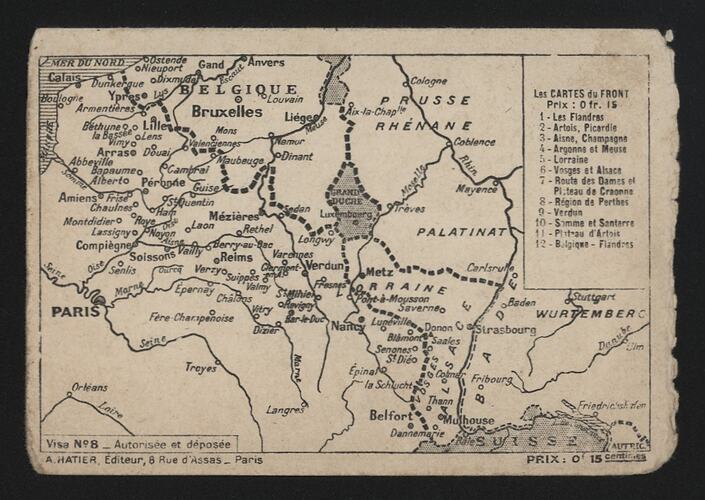
Postcard - 'Les Cartes du Front', visa no.8, published by A. Hatier, 8 Rue d'Assas, Paris, during World War I.
At the outbreak of World War I in 1914, many of the smaller townships along the eastern French border would have been all but unknown to most Australians. Names such as Bapaume, Cambrai, Lille and Ypres would become highly recognisable sites of heavy fighting in the years ahead, and increasingly, after the failed Gallipoli campaign of 1915, would involve Australian military forces being redirected to European theaters of war.
Physical Description
Printed postcard map titled 'Les Cartes du Front' published by A. Hatier, 8 Rue d'Assas, Paris, depicting the area of the Western Front during the First World War from the northern French coastline through to the Swiss border. Although the front line itself is not marked, all the major towns and cities along the front are shown, as are the country borders in the area for France, Belgium, Luxembourg, Switzerland and Germany. There is an index numbered 1 to 12 in the upper right corner of the image.
Significance
This French First World War postcard depicting the geography of the Western Front illustrates the 'foreignness' that France represented to many Australian soldiers, often travelling overseas for the first time. Such documents enhance our representation of military life, highlighting the culture of communication of soldiers on active duty.
More Information
-
Collecting Areas
-
Acquisition Information
Purchase
-
Publisher
-
Inscriptions
Recto, index titled, upper rh corner: Les CARTES du FRONT./ Prox: 0 fr. 15 Recto, text, lower lh corner: Visa No 8-Autorisse et deposse/ A. HATIER, Editeur, 8 Rue d' Assas-Paris Reto, text, lower rh corner: PRIX: 0 15 centimes Verso, heading text, upper margin: CORRESPONDANCE DES ARMEES/ FRANCHISE MILITAIRE Verso, body text, upper: Partie Reservee a la Correspondance/ Adresse du Destinataire Verso, body text, lh column: Nom et adresse/ de/ l'Expediteur Verso, body text, rh column: Nom/ Grade/ ou/ Emploi/ a/ (1) Ville et Departement ou Secteur
-
Classification
-
Category
-
Discipline
-
Type of item
-
Overall Dimensions
13.9 mm (Width), 9.5 mm (Height)
-
Keywords