Summary
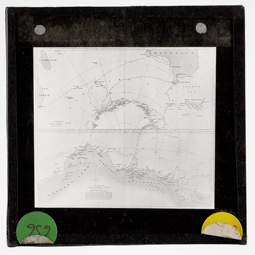
Lantern slide of a map showing the tracks of the Discovery - 1929-30, 1930-31 and a track for the 1,000 fathom line (approx). A split slide - showing the Banzare Expedition of 1929/30 and 1930/31 in two voyages.
One of 328 images in various formats including artworks, photographs, glass negatives and lantern slides.
Description of Content
Two charts of Antarctica depicting BANZARE Voyages of 1929-1931. A split slide showing the tracks of BANZARE Voyages of 1929-1930 and 1930-1931. Also shown is a track of the 1,000 ft fathom line. Eric Douglas said on this 'The chart is from sketch surveys made by the BANZARE Expedition during the Summer seasons of 1929-1930 and 1930-1931, adjusted by frequent astronomical observations taken on board the Discovery and at Scullin Monolith. The coastline with the exception of the parts shown by thicker lines, consists of inaccessible ice cliffs, 100 to 150 feet high. Kemp Land west of Cape Heard was chartered from the Gipsy Moth seaplane at a height of 5,500 feet. Large numbers of icebergs were found at varying distances from the land. The new names on this chart were those proposed by Sir Douglas Mawson'. The map resulting from these charts was published by the Royal Geographical Society, London, in August, 1932 and is called 'Antarctic Regions - Mawson'.
Physical Description
Standard format lantern slide, consisting of two glass sheets each 3.25 x 3.25 ins (83 x 83mm), one pane bearing a positive transparent image and the other pane protecting the image. Sealed with paper binding strips around the four edges of the lantern slide and internally framed with a black cut-out window mask.
More Information
-
Collection Names
-
Collecting Areas
-
Acquisition Information
Donation from Sally Douglas, 10 Oct 2008
-
Place & Date Depicted
-
Creator
-
Publisher
-
Expedition Leader
-
Format
Lantern Slide, Standard (3¼ in. x 3¼ in.), Monochrome
-
Language
English
-
Classification
-
Category
-
Discipline
-
Type of item
-
Image Dimensions - Mount
82 mm (Width), 82 mm (Height)
-
References
[Article] Douglas, Sally. Eric Douglas Antarctica Collection at Museum Victoria.
-
Keywords