Summary
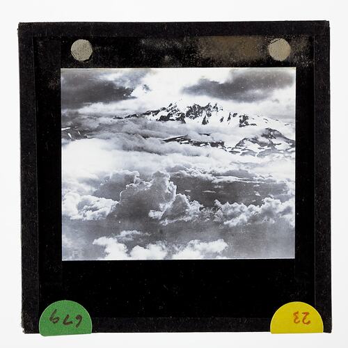
Lantern slide of an aerial view of Mount Ross, the highest peak - 6,000 feet above sea level - on Kerguelen Island, sub- Antarctica.
One of 328 images in various formats including artworks, photographs, glass negatives and lantern slides.
Description of Content
Summit of Mount Ross, Kerguelen Island. Eric Douglas captioned the image 'Aerial view of Mount Ross Kerguelen Island - 6000 feet above sea level'. Mount Ross is the highest mountain in the Kerguelen Islands. It is a Volcanic cone. Kerguelen was often referred to as Kerguelen Island but it is in fact consists of one main island 'Grand Terre' and some hundreds of smaller islands. When Kerguelen initially became French Territory it was part of the French Colony of Madagascar. Photograph taken during the British Australian New Zealand Antarctic Research Expedition (BANZARE), Voyage 1.
Physical Description
Standard format lantern slide, consisting of two glass sheets each 3.25 x 3.25 ins (83 x 83mm), one pane bearing a positive transparent image and the other pane protecting the image. Sealed with paper binding strips around the four edges of the lantern slide and internally framed with a black cut-out window mask.
More Information
-
Collection Names
-
Collecting Areas
-
Acquisition Information
Donation from Sally Douglas, 10 Oct 2008
-
Place & Date Depicted
-
Photographer
-
Expedition Leader
-
Format
Lantern Slide, Standard (3¼ in. x 3¼ in.), Monochrome
-
Language
English
-
Classification
-
Category
-
Discipline
-
Type of item
-
Image Dimensions - Mount
82 mm (Width), 82 mm (Height)
-
References
[Article] Douglas, Sally. Eric Douglas Antarctica Collection at Museum Victoria.
-
Keywords