Summary
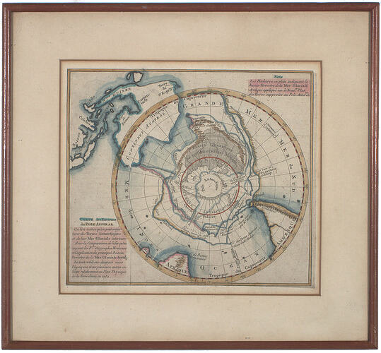
Hand coloured lithograph of a map of area of the Southern Pole. The map from which this lithograph was created was made by an unknown cartographer in 1752. The lithograph was purchased around 1954 in an open book stand on the left bank of the Seine in Paris by Dr Philip Law, Director of the Australian Antarctic Division and leader of ANARE (Australian National Antarctic Research Expedition) from 1949-1966.
Physical Description
Hand coloured lithograph of a map of the Southern Hemisphere. The map is relatively circular with words printed in the top right and bottom left hand corners. The map is surrounded by a cardboard border; as well as a thin wooden frame with a sheet of glass. Brown paper has been glued and taped on the back. Gold wire is drawn from two hooks on either side of the back of the print. Blue, red, yellow and pink colours are all used in the map.
More Information
-
Collection Names
-
Collecting Areas
-
Acquisition Information
Donation from Dr Phillip G. Law AC CBE - Australian Antarctic Division, 02 Feb 1993
-
Place Made
-
Place & Date Used
Dr Phillip G. Law AC CBE - Australian Antarctic Division, Antarctica, 1954-1966
-
Inscriptions
Printed/stencilled, black ink, " [extensive text] / CARTE des Environs / du POLE AUSTRAL / [extensive text] "
-
Classification
-
Category
-
Discipline
-
Type of item
-
overall dimensions
34.1 cm (Length), 2 cm (Width), 31.5 cm (Height)
-
Framed
344 mm (Width), 22 mm (Depth), 316 mm (Height)
External dimensions of frame including hooks at rear.
-
Primary support
226 mm (Width), 196 mm (Height)
Laid paper
-
Secondary support
330 mm (Width), 303 mm (Height)
Cardboard mat
-
Keywords


