Summary
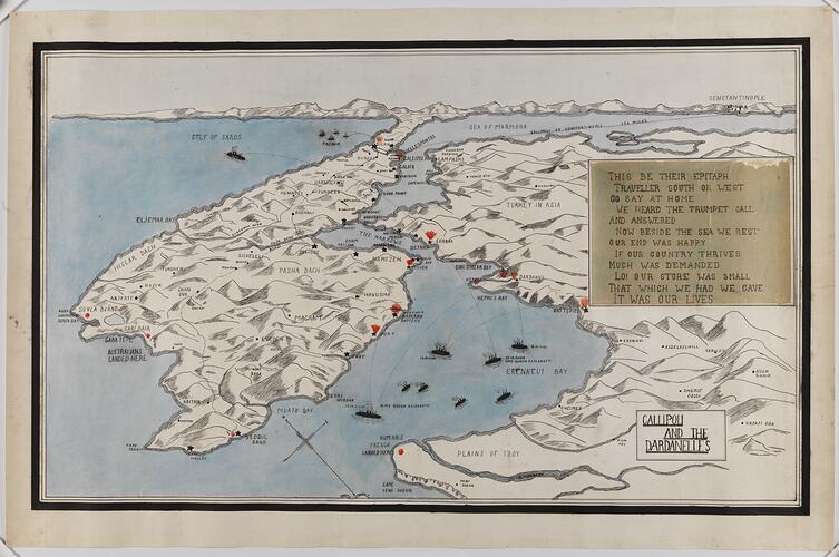
Map of Gallipoli & the Dardanelles, drawn by Amy Palmer (later Lavey) for State School No. 1508, Glenferrie Exhibition of Children's Work, Hawthorn Town Hall, in 1921. Amy was aged 13 years. The map was also exhibited at the Jubilee Exhibition of Children's Work in the Combined Schools of Victoria Jubilee in 1922.
Other maps drawn by Amy Palmer (Victoria, Tasmania, New Zealand and North America) and exhibited at this time are also held by Museum Victoria. She also won second prizes for freehand, scones, 'mission box gift' and 'most useful article from waste', and a first prize for a camisole.
State School No. 1508 was Hawthorn State School, in Manningtree Road, Hawthorn. It has also been known as Manningtree Road School, Central School and Glenferrie Primary School, its current name.
The choice of the Dardanelles and the patriotic statement of the map, seven years after the Anzac landing, underlines the continuing presence of World War I in popular memory.
Physical Description
Hand-drawn and coloured map of Gallipoli and the Dardanelles with a verse written by hand.
More Information
-
Collecting Areas
-
Acquisition Information
Donation from Mrs Amy D. Lavey, 21 Oct 1985
-
Maker
Amy Palmer, Hawthorn, Greater Melbourne, Victoria, Australia, 1921
-
Place & Date Depicted
Gallipoli Peninsula, Turkey, 1915-1918
Likely date depicted. -
Commissioned By
-
Place & Date Exhibited
Hawthorn Town Hall, Hawthorn, Greater Melbourne, Victoria, Australia
-
Inscriptions
Hand-written text: THIS BE THEIR EPITAPH/TRAVELLER SOUTH OR WEST/ GO SAY AT HOME/WE HEARD THE TRUMPET CALL/AND ANSWERED/NOW BESIDE THE SEA WE REST /OUR END WAS HAPPY/IF OUR COUNTRY THRIVES/MUCH WAS DEMANDED/LO! OUR STORE WAS SMALL/THAT WHICH WE HAD WE GAVE/IT WAS OUR LIVES.
-
Classification
-
Category
-
Discipline
-
Type of item
-
Primary support
759 mm (Width), 494 mm (Height)
-
Keywords
Cartography, Education, Illustrations, Military History, Wars & Conflicts, World War I, 1914-1918, Students, School Students' Work, Maps, Exhibitions, Anzacs