Summary
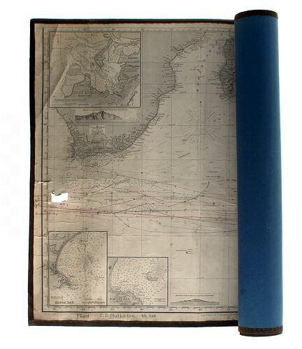
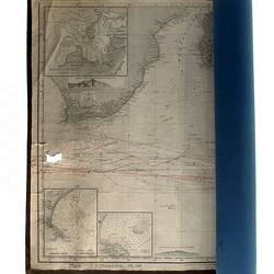
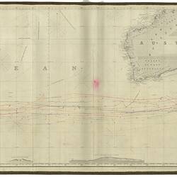
Untitled map of the Southern and Pacific Oceans, published by Charles Wilson (late J.W. Norie & Wilson) on 1st March 1873.
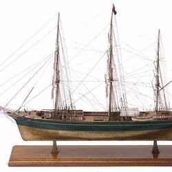
The map shows the plotted courses of 17 voyages by the White Star Line ships Patriarch, Thermopylae and Ethiopian between 1880 and 1891. The chart also shows detailed soundings of several harbours and etched elevations of first land falls along the 'Roaring Forties' shipping route to Australia.
The chart was owned by Charles Davy Matheson and possibly also by his father Captain Charles Matheson who commanded both the Thermopylae and Ethiopian.
Physical Description
Untitled map of the Southern and Pacific Oceans covering an area from Latitude 15 to 53 degrees South and Longitude 15 degrees East to 170 Degrees West. The map shows the plotted courses of 17 voyages by the Patriarch, Thermoplae and Ethiopian, between 1880 and 1891. The chart also shows detailed soundings of several harbours and etched elevations of first land falls along the 'Roaring Forties' shipping route to Australia.
More Information
-
Collection Names
-
Collecting Areas
Engineering, Migration & Cultural Diversity, Science & Measurement, Transport
-
Acquisition Information
Donation from Mrs Marjory B. Miller, by Dec 1994
-
Publisher
Charles Wilson (late J.W. Norie & Wilson), 157 Leadenhall Street, London, England, Great Britain, 01 Mar 1873
-
User (Probable)
Captain Charles Matheson, England, Great Britain, circa 1873-1884
-
User
Charles D. Matheson, England, Great Britain, circa 1884-1920
-
Inscriptions
Printed: Published as the Act Directs, March 1st 1873, by Charles Wilson (late J.W. Norie & Wilson) at Navigation Warehouse and Naval Academy, No. 157 Leadenhall Street, London.
-
Brand Names
-
Classification
-
Category
-
Discipline
-
Type of item
-
Overall Dimensions
204 cm (Length), 59 cm (Width)
-
Exhibition Collection Management
204 mm (Length), 59 mm (Width)
-
References
"Clippers for the Record, The Story of Ship Thermopylae, S.S. Aberdeen and Captain Charles Matheson", Marny Matheson, Spectrum Publications, Melbourne,1984.
-
Keywords
Clipper Ships, Immigration, Navigation, Sailing Vessels, Shipping Lines