Summary
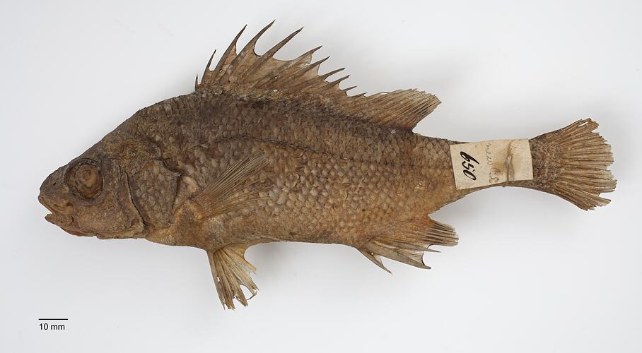
This specimen was collected during William Blandowski's expedition to the junction of the Murray and Darling Rivers (December 1856 - December 1857). One of the first fish collected on the expedition, it came from 'the waters of the billybongs' near the first base camp, Gunbower Station, between 16-28 February. The original tag '650' is intact and the specimen is listed in the expedition register by its local Koorie name 'Pollungunder'.
Blandowski illustrated this species on 25 February 1857 (Museum fur Naturkunde, Berlin, B X/613), noting the local name 'Pollugunder'. In his expedition report for the 'Transactions of the Philosophical Institute of Victoria' in 1858, he described and named it Tilka wilsonia in honour of Professor William Wilson, Vice-President of the Institute. Blandowski also included the name 'Pollugunder', along with another Koorie name 'Birnnett' from the Loddon River area, recognising that Aboriginal people in different areas of the Central Murray region knew this species by different names.
Unfortunately for Blandowski, his decision to name fishes after members of the Committee of the Philosophical Institute created considerable controversy, resulting in the descriptions being suppressed from publication that same year. This species had already been described by the French naturalist Georges Cuvier in 1830 as Macquaria australasica, so had the name Tilka wilsonia been published, it would have been considered a junior synonym for the Macquarie Perch and not used.
Once widespread, mostly in the cooler upper reaches of the Murray-Darling Basin, the Macquarie Perch has undergone a dramatic decline in distribution and abundance, and no longer occurs in the Central Murray Catchment. The species is now listed nationally as Endangered under the EPBC Act 1999, and as Threatened under the Victorian Flora and Fauna Guarantee Act 1988.
Classification
Specimen Details
-
Collection Names
-
Taxon Name
-
Author and date of publication
Cuvier, 1830
-
Preferred Common name
Macquarie Perch
-
Date Identified
05/06/2007
-
Identified By
Dianne J. Bray - Museums Victoria
-
Number Of Specimens
1
-
Sex
Unknown
-
Stage Or Age
Juvenile
-
Specimen Nature
Nature: Skin, Form: Dry
-
Expedition Name
Blandowski expedition to the junction of the Murray and Darling Rivers
-
Collected By
William Blandowski
-
Date Visited From
16/02/1857
-
Date Visited To
28/02/1857
-
Category
-
Scientific Group
-
Discipline
-
Collecting Areas
-
Type of Item
Taxonomy
-
Kingdom
-
Phylum
-
Subphylum
-
Superclass
-
Class
-
Order
-
Family
-
Genus
-
Species Name
australasica