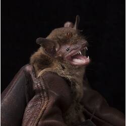
Specimen Details
- 
                            Taxon Name
- 
                            Author and date of publicationGould, 1858 
- 
                                Preferred Common nameEastern False Pipistrelle 
- 
                            Date Identified27/11/2013 
- 
                            Identified ByKevin C. Rowe - Museum Victoria 
- 
                            Number Of Specimens1 
- 
                            SexMale 
- 
                            Stage Or AgeAdult 
- 
                            Specimen NatureNature: Skin, Form: Dry 
- 
                            Date of preparation27/11/2013 
- 
                                Expedition Name
- 
                                Collected ByTony Mitchell - Department of Sustainability and Environment 
- 
                                Collection Event CodeALB 2013 0835 
- 
                                Sampling MethodHarp trap 
- 
                                Date Visited From27/11/2013 8:00 AM 
- 
                                Date Visited To27/11/2013 8:00 AM 
- 
                            Category
- 
                            Scientific Group
- 
                            Discipline
- 
                            Collecting Areas
- 
                            Type of Item
Taxonomy
- 
            Kingdom
- 
            Phylum
- 
            Subphylum
- 
            Class
- 
            Order
- 
            Family
- 
            Subfamily
- 
            Genus
- 
            Species Nametasmaniensis 
Geospatial Information
- 
                                    Site CodeABSite 0822 
- 
                                    Country
- 
                                    State
- 
                                    Nearest Named Place
- 
                                    Precise LocationAlpine National Park, Davies Plain Track, 15.53 km south east of Mt Pinnibar summit, and 8.67 km north east of junction with Kings Plain 4WD Track 
- 
                                    Minimum Elevation1405 
- 
                                    Maximum Elevation1405 
- 
                                    Latitude-36.634 
- 
                                    Longitude148.127 
- 
                                    Geodetic DatumWGS84 
- 
                                    Georeference SourceGoogle Earth 
- 
                                    Georeference Protocolamg conversion 
- 
                                    Georeference ByKaren K. Roberts