The Geodetic Survey of Victoria was established in 1858 by Surveyor-General Charles Ligar to undertake a triangulated survey of Victoria, taking into account the curvature of the earth's surface. The Geodetic Survey would thereby provide an accurate set of survey markers that could be used by government and commercial surveyors for all subsequent surveys. Existing magnetic surveys were too unreliable to form the long-term basis for legal titles to land and for expansion of settlement.
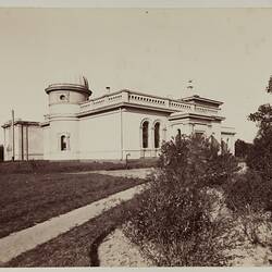
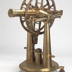
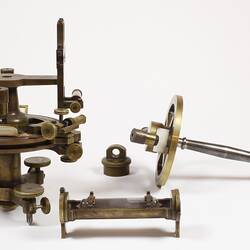
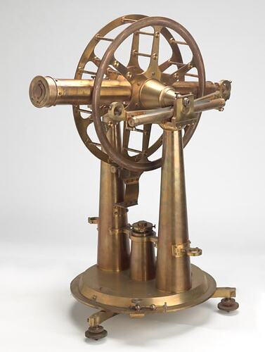
Victorian Government Astronomer and Director of Williamstown Observatory, Robert Ellery, was placed in charge of the project, because the work required highly accurate measurements and astronomical observations. Ellery superintended the measurement of a Standard Meridian at Williamstown Observatory using a portable transit telescope by Troughton & Simms (ST 022217). A base line for the survey was then measured at Werribee, because the Werribee Plains provided the closest relatively flat land near Williamstown.
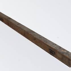
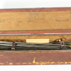
Measurement of the 5 mile baseline commenced in January 1860 from the South Base Stone at a site near the Werribee Railway Station. The baseline measuring apparatus consisted of three iron measuring bars (ST 039785) made in Victoria against the NSW standard obtained from the Ordnance Survey Department of Southampton, England. The rods were mounted on heavy brass tripods called camels mounted in turn on timber trestles, and leapfrogged along the length of the line. The measuring bars were encased in wooden cases with approximately 2 inches protruding, and were protected from exposure to the elements by an A-frame segmented tent structure. Tent bearers would move the structure forward when one measurement was complete and this process was continued for the entire length of the baseline. The measure of the base took 4 months commencing on 29 January 1860 and completed on 29th May, with the installation of a North Base Stone. The base line was then extended by careful triangulation to the Green Hill extension marker on the saddle of Green Hill, completed by June the 12th 1860. [The South Base Stone and North Base Stone at Werribee are listed on the Victorian Heritage Register (H1957).]
The Geodetic Survey took a further 12 years to complete, as Ellery directed surveyors to spread the triangulation across the colony. Surveying in heavily wooded and hilly areas such as Gippsland proved to be very time consuming, requiring the use of heliotropes directing light from mountain to mountain. One of the last operations was the marking of the boundary line between Victoria and New South Wales from the source of the Murray River to Cape Howe.
Notes from Public Record Office of Victoria:
Robert Ellery to G B Airy (Astronomer Royal, Greenwich Observatory), 16 Nov 1859 (VPRS 775, Vol 1)
'In the field our work is progressing but the heat of the summer shortens the hours of Trigonometrical observing very much, but the splendid clearness of the atmosphere & distinctness of distant objects in the morning & evening almost compensates for the short day's work. I have been engaged for several weeks preparing for the measurement of Base line - especially in the comparison of standard measures & of the bars to be used in the field - The bars we shall use are of iron 10 feet long and intended to be used by contact.'
Robert Ellery to Surveyor-General, South Australia 18 Jan 1889 [1888 on letter] VPRS 775, Vol 4
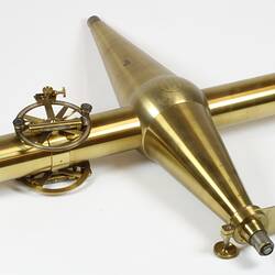
'In a room at the Lands Department an arrangement for comparing standards similar to that used by the Royal Engineers at Southampton was erected, stone piers built, microscopes fitted, and a traveling platform with camels or compound screw jacks for carrying the standard bar as well as the measuring bars. The three measuring bars were ten feet steel bars one end of each was polished square and flat and the other spherical. These bars were carefully compared with our ten foot ordnance standard and corrections obtained under several temperatures. After the line had been carefully aligned and leveled trestles were arranged on which the camels were placed and the bars laid on these at a convenient height above the ground. A solid masonry pier the surface of which was somewhat below the ground surface was built at both ends and a gunmetal plug let into the center of the top stone, in the center of this plug a small platinum plug was inserted and a fine dot in the platinum formed the terminus in each case. The mode of measurement was about throughout. The bars being aligned leveled and temperatures read were brought within about half an inch of one another and the space measured by a graduated wedge. For starting from the terminals or from any point where levels were changed (for the base was measured in a series of steps to suit the ground) a special apparatus we called a vertical surface telescope was used. This was a vertically revolving telescope of high power capable of being accurately collimated and adjusted for verticality and having a steel cross head for measuring the distance between the bar and the line of collimation. Whenever it was necessary to raise or lower the next range of bars this telescope was put up and a solid block of iron with an adjustable reference point was placed on the ground to form a temporary terminus and new starting point. The base line was measured once with level bars in steps and once with bars following the inclination of the ground approximately and measuring the inclination of the bars with a delicate clinometer. The results were excellent and highly satisfactory. This was done now over thirty years ago and there have been many improvements in base line measurement. If I were to commence again I think I should adopt the Cape method.'
More Information
-
Keywords
-
Authors
-
Article types