The Shire of Donald was located in the Wimmera region of north-western Victoria by the Richardson River, 10km south of Lake Buloke. The lake is freshwater, and forms the terminal outlet of the Richardson-Avon River System. The Lake Buloke area comprises wetland habitat of high significance for waterbirds, particularly waterfowl and waders.
The area is thought to have been occupied by the Wemba-Wemba. Thomas Mitchell and his surveying party were the first Europeans known to have entered the area.
Donald developed on the Banyenong Run of brothers James, William and John Donald, who settled in 1844. Their homestead became a social centre for settlers on the Richardson River by the 1860s, in part to the racecourse they laid out nearby. William Donald played an important role in the development of the shire, but the township was established when Johann Meyer, a German migrant to the goldfields, set up a shanty and began to sell alcohol in 1863 at 'The Bridge' or 'Richardson Bridge'. Meyer later went on to build two hotels and selected land for wheat cultivation. In 1866 the nascent town was surveyed and re-named Donald.
The St Arnaud Road District was created on 25 June 1861. The Shire of St Arnaud was formed in 1864; 33 years later, on 11 February 1897, it became the Shire of Donald.
In 1864 a police lock-up was built. In 1874 a brick cottage was built that housed the police station until 1911-12. Stables were added in 1883.
German, Cornish and Irish selectors began to arrive in the 1870s, many leaving the goldfields.
Donald itself became a Town in 1872. Donald developed as a service centre to the surrounding district where wheat, barley, fat lambs and wool were the main produce; in recent years crop diversification has seen peas, canola and safflower also grown.
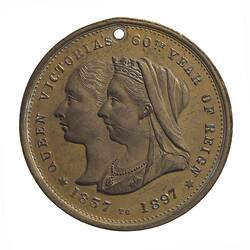
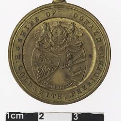
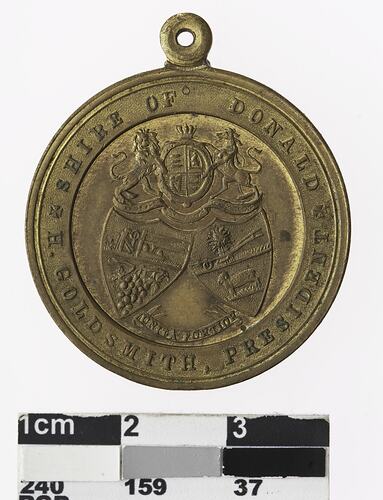
In 1897 the Shire of Donald commissioned a medal to commemorate Queen Victoria's jubilee [NU 20463].
On January 20 1995 the Shires of Donald, Birchip, Charlton and Wycheproof, and part of the Shire of Kara Kara, were united by order of the Governor in Council to form the Buloke Shire Council.
References:
Blake, L. (1977). Place Names of Victoria.
Municipal Association of Victoria website http://www.mav.asn.au/, accessed 10/12/2003.
Register of the National Estate website http://www.ahc.gov.au/cgi-bin/ahdb/search.pl?mode=place_detail;place_id=17257 Fairfax Walkabout Australia Travel Guide website http://www.walkabout.com.au/locations/VICDonald.shtml, accessed 10/12/2003.
Maroske, I.O. & Kirk, L. (1997). Shire of Donald 1897-1995: A Municipal History. Buloke Shire Council, accessed 10/12/2003.
More Information
-
Keywords
-
Localities
-
Authors
-
Article types