Doncaster, formerly an orchard area, is a residential area east-north-east of Melbourne. It existed as a municipality from 1890 to 1994.The first settlement in the area began west of the later Shire of Doncaster, with Unwin's Special Survey in Bulleen in 1841. In 1854 John Robert Wilson, from Doncaster in Yorkshire, England, built the Doncaster Arms Inn on the track through the stringybark forest to the Warrandyte gold diggings. The track was later named Doncaster Road. William Burnley, a Richmond land developer, sold land in the area in the 1850s. He was also from Doncaster, England. Either may be the source of the name Doncaster.
By the 1850s settlements had begun to develop along the Koonung Koonung Creek and other streams in the Doncaster area. Some of the settlers were German immigrants, including Gottlieb Thiele, who built a two roomed-mud and lath homestead in 1853 which he named 'Friedensruh' meaning 'rest in peace'. Gottlieb was a military tailor and unsuccessful prospector with little knowledge of farming, but he built a successful orchard with his family. Deeply religious, he held services in his house until a Lutheran church opened in the area in 1858. A Lutheran school opened two years later, and a denominational school in 1861. The German community was named Waldau, but the name Doncaster prevailed.
Early settlers earned income from timber and fire wood. The cleared land proved suitable for growing cereals, vegetables and fruits. Orchards were more profitable and predominated in the long term, including citrus and stone fruits.
In 1877 a rustic look-out tower was built beside Doncaster Road. It attracted visitors from the 1888 Centennial International Exhibition in Melbourne. The Exhibition also featured an electric tram, a prototype for a service from Box Hill to Doncaster that opened in 1889. The service only lasted until 1896 with services running intermittently, mainly to carry visitors to the look-out tower that was a popular recreation spot on weekends and public holidays.
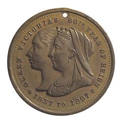
Between 1875 and 1890 Doncaster was part of the Bulleen Shire. On 30 May 1890 the Shire of Doncaster was established. Fruit growing developed as the basis for Doncaster's economy, and a fruit growers' association was formed in 1892. In 1897 the Shire issued a medal for Diamond Jubilee of Queen Victoria [NU 20187].
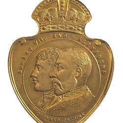
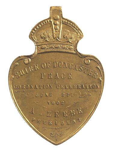
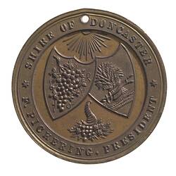
In 1902, when the Shire issued a medal to commemorate the coronation of Edward VII (NU 20243), it boasted four churches, two state schools, three hotels, a bank and a post office. It had a population of 1,037 living in 215 houses, and covered 13 and a half square miles. Doncaster did not develop as a residential area until the 1960s and 70s.
By 1911 Doncaster was home to 1158 people. Four years later in 1915, Doncaster and the former Bulleen Shires were united as Doncaster and Templestowe Shire. By 1947 the population had expanded to 1538 people. Between 1950 and 1955 the Shire's population grew at an annual average of 5%, and in the next five years the annual average growth was 28%.
In 1963 G. J. Coles and Coy. Ltd. acquired a nine acre site at the intersection of Doncaster and Williamsons Roads, were the lookout tower previously stood. The corner then had a landmark two-storey general store. Later in the decade Westfield built Doncaster Shopping town on the site.
On 15 December 1994 part of City of Doncaster and Templestowe, and part of the Shire of Lillydale, united to form the Manningham City Council. On the same day the remaining part of the City of Doncaster united with the Cities of Croydon and Ringwood, part of Templestowe and Shire of Lillydale to form the Maroondah City Council.
At the start of the 21st century Doncaster had several primary schools, a secondary college and several neighbourhood reserves. The Doncaster Municipal Gardens provided large-scale open space.
References:
Australian Places website, Monash University, http://arts.monash.edu/ncas/multimedia/gazetteer/list/doncaster.html, accessed 11/12/2003.
Municipal Association of Victoria website http://www.mav.asn.au, accessed 11/12/2003.
Blake, L. (1977). Place Names of Victoria.
Victorian Heritage Register on-line http://www.doi.vic.gov.au/doi/hvolr.nsf, accessed 11/12/2003.
More Information
-
Keywords
-
Localities
-
Authors
-
Article types