Summary
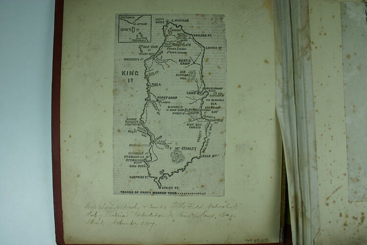
This map is one of thirty-two black and white photographs in an album [two are loose] taken by A J Campbell during a Field Naturalists' Club of Victoria expedition to King Island. Map shows tracks & camps of the expedition, November 1887.The album also includes maps of King Island in the inside front cover and back page and numerous newspaper clippings relating to the expedition. One of the newspaper clippings, written by one of the members of the party, documents the mission of the expedition thus: 'It is our intention, before the introduction of numerous foreign plants and animals rendered it impossible to do so, to ascertain as precisely as we could in the short time at our disposal the fauna and flora indigenous to the island.' The map show the location of the camp and tracks they took on the trip.
Description of Content
Black and white line drawing of Kind Island and it's georgraphic features.
Physical Description
Black and white newsprint
More Information
-
Collection Names
-
Collecting Areas
-
Acquisition Information
Transfer from Museum Archive, Museum Victoria, 13 Dec 2006
-
Place & Date Depicted
-
Photographer
-
Organiser of Expedition
Field Naturalists Club of Victoria, Kent Island Group, Bass Strait, Tasmania, Australia, 1887
Information ascertained from newspaper reports of the day preserved with the photograph in the album. -
Format
Print, Black & White
-
Language
English
-
Inscriptions
Printed on map: "KING Id." Handwritten in black ink below the map: "Map showing tracks & camps of The Field Naturalists' Club of Victoria's Expedition to King Island, Bass Straits, November 1887."
-
Classification
-
Category
-
Discipline
-
Type of item
-
Image Dimensions
117 mm (Width), 188 mm (Height)
-
Keywords
