Summary
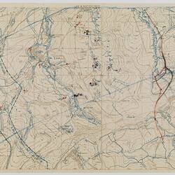
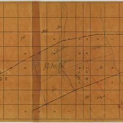
Trench map of Jeancourt Sector with trace overlay, scale 1:20,000, made and used during World War I. It is dated 14 September 1918, and is inscribed 'Field Survey Battalion RE, 4340. Places on the map include Jeancourt, le Verguier, Pontruet and Berthaucourt. The map is printed with trench locations; battalion locations have been marked by hand.
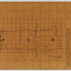
Accompanying the map is an identification trace map, showing the locations of the 1st and 4th Australian Divisions, and the 13th, 14th, 16th, 45th, 46th and 48th Battalions. Identification trace maps were printed as means of transferring the position of targets located on more detailed artillery maps (see example ST 040579). The squares on the trace map represent 500 yards if the artillery map scale is 1/10,000; 1,000 yards if the scale is 1/20,000 and 2,000 yards if the scale is 1/40,000. When used, the scale of the original artillery map always needed to be noted. In this case, the map is labelled '1:20,000'.
Physical Description
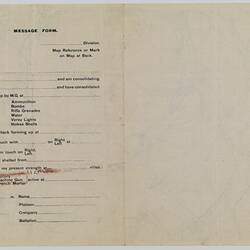
ST 040583.1: Map printed in brown on off-white paper, with trenches printed in blue, and battalion and other locations hand-marked with a crossed circle in black and red. On the back of the map is a 'Message form' with multiple choice answers. The map is stained with red and brown substances on left and right edges. ST 040583.2: A trace overlap of the map printed on translucent orange paper, marked into squares.
More Information
-
Collection Names
-
Collecting Areas
-
Acquisition Information
Donation from J. Lord, 1986
-
Place & Date Depicted
-
Organisation Named
-
Past Owner
-
Inscriptions
Printed across top: '1:20,000 / JEANCOURT / PARTS OF 62C N.E., 62C S.E., 62B N.W., 62B S.W.' Printed at lower left: 'FIELD SURVEY BN. R.E. (4340) 14.9.18'.
-
Classification
-
Category
-
Discipline
-
Type of item
-
Primary support
425 mm (Width), 288 mm (Height)
part one - on wove paper
-
Primary support
545 mm (Width), 380 mm (Height)
Part two on tracing paper
-
Keywords