Summary
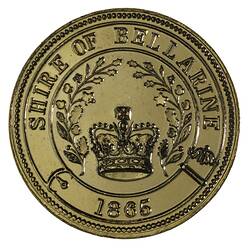
Australia Victoria Shire of Bellarine
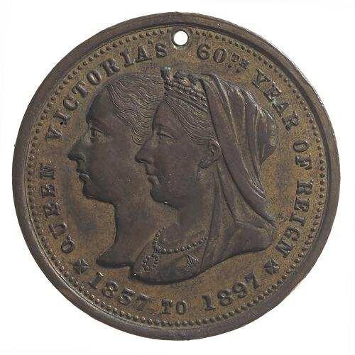
Queen Victoria's Diamond Jubilee 1897 (AD)
Mint: not recorded
Other Details: Queen Victoria's diamond jubilee in 1897 was celebrated the great enthusiasm throughout the British Empire. It prompted many Australian local governments to issue commemorative medals, including the Shire of Bellarine. Bellarine is a rural locality to the west of Melbourne on the northern side of the Bellarine Peninsula, between Clifton Springs and Portarlington. A Presbyterian church and a school were established in about 1854, the year the Bellarine road district was declared. Four years later a mechanics' institute was founded, and in 1865 a Wesleyan church and school opened. On 18 September that year the Bellarine shire was proclaimed. It extended from Geelong to Ocean Grove, occupying all of the Bellarine Peninsula except Queenscliff. Other coastal townships included Clifton Springs, Indented Head, Portarlington, Ocean Grove and St. Leonards. Inland were the Drysdale township and farmlands with good soil for agriculture. The Shire headquarters were located in Drysdale. By 1871 Bellarine municipality's census population was 3,802. The Peninsula's industries included creameries, wattle liquor factories and boiling-down works; its primary industries focussed on vegetable-growing.
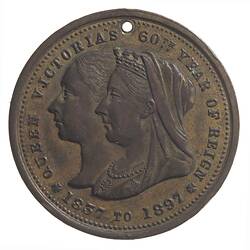
Obverse Description
Jugate busts, young & old Queen Victoria; around, QUEEN VICTORIA'S 60TH YEAR OF REIGN * 1837 TO 1897 * (stops on either side of date in form of crosses);
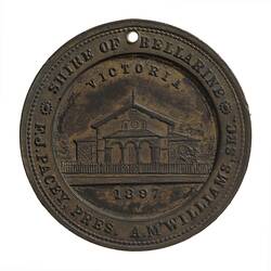
Reverse Description
At centre within wide rim view of front of Shire Hall; above, VICTORIA , in exergue, 1897; around on broad rim, SHIRE OF BELLARINE * F.J. PACEY, PRES. A. M'WILLIAMS, SEC. *
Edge Description
Plain
Significance
Queen Victoria's diamond jubilee in 1897 was celebrated the great enthusiasm throughout the British Empire. It prompted many Australian local governments to issue commemorative medals, including the Shire of Bellarine. Bellarine is a rural locality to the west of Melbourne on the northern side of the Bellarine Peninsula, between Clifton Springs and Portarlington. A Presbyterian church and a school were established in about 1854, the year the Bellarine road district was declared. Four years later a mechanics' institute was founded, and in 1865 a Wesleyan church and school opened. On 18 September that year the Bellarine shire was proclaimed. It extended from Geelong to Ocean Grove, occupying all of the Bellarine Peninsula except Queenscliff. Other coastal townships included Clifton Springs, Indented Head, Portarlington, Ocean Grove and St. Leonards. Inland were the Drysdale township and farmlands with good soil for agriculture. The Shire headquarters were located in Drysdale. By 1871 Bellarine municipality's census population was 3,802. The Peninsula's industries included creameries, wattle liquor factories and boiling-down works; its primary industries focussed on vegetable-growing. -Australian Places web site, Monash University, http://arts.monash.edu/ncas/multimedia/gazetteer/list/bellarine.html; Blake, L. 1977. Place Names of Victoria. Rigby. -D. Tout-Smith 25/11/2003.
More Information
-
Collecting Areas
-
Acquisition Information
Transfer from National Gallery of Victoria (NGV), Colonel R. A. Crouch, 15 Mar 1976
-
Date Issued
1897 AD
-
Issued By
-
Mint
Stokes & Sons, Melbourne, Greater Melbourne, Victoria, Australia, 1897
-
Commissioned By
-
Person Depicted
-
Person Named
Mr Frederick John Pacey JP - Shire of Bellarine, Ballarat, Victoria, Australia, 1897
Named as Shire President on this medal -
Person Named
Andrew McWilliams - Shire of Bellarine
Named as Shire Secretary on this medal. The reverse reading 'A. M'Williams' must be an abbreviation - it may be for Mac rather than Mc. -
Inscriptions
(edge) (obverse) (reverse)
-
Series
-
Material
Gilt
-
Axis
12
-
Classification
-
Category
-
Discipline
-
Type of item
-
Overall Dimensions
31 mm (Outside Diameter), 12.43 g (Weight)
-
Shape
Round
-
References
Car. 1897/49
-
Keywords
Architecture, Celebrations, Queen Victoria Diamond Jubilee, 1897, Royal Anniversaries, Town Halls