Specimen Details
-
Taxon Name
-
Author and date of publication
(White, 1790)
-
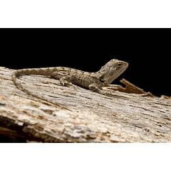
Preferred Common name
Jacky Lizard
-
Date Identified
21/11/2012
-
Number Of Specimens
1
-
Sex
Female
-
Specimen Nature
Nature: Spirit, Form: Wet, Fixative treatment: formalin 10%, Medium: ethanol 70%
-
Date of preparation
21/11/2012
-
Expedition Name
-
Collected By
Dr Kevin C. Rowe - Museums Victoria
-
Collection Event Code
GRB 462
-
Sampling Method
Mammal traps
-
Date Visited From
18/11/2012
-
Date Visited To
22/11/2012
-
Category
-
Scientific Group
-
Discipline
-
Collecting Areas
-
Type of Item
Taxonomy
-
Kingdom
-
Phylum
-
Subphylum
-
Class
-
Subclass
-
Order
-
Suborder
-
Infraorder
-
Family
-
Genus
-
Species Name
muricatus
Geospatial Information
-
Site Code
GRBS 2012 32
-
Country
-
State
-
Precise Location
Grampians National Park, Longpoint Track, 3km by road N of intersection with Mount Difficult Road
-
Minimum Elevation
488
-
Latitude
-37.0132
-
Longitude
142.457
-
Geodetic Datum
WGS84
-
Site Radius
200
-
Georeference Source
GPS
-
Georeference Protocol
gps
-
Georeference Date
2012-11-18T00:00:00
-
Georeference By
Dr Kevin C. Rowe - Museums Victoria